
Gesamtpreis (1 Artikel Artikel):
Versandziel:

marienbad: Karten (10 Ergebnisse)
Feedback
Direkt zu den wichtigsten Suchergebnissen
Suchfilter
Produktart
- Alle Product Types
- Bücher (1.334)
- Magazine & Zeitschriften (7)
- Comics (Keine weiteren Ergebnisse entsprechen dieser Verfeinerung)
- Noten (2)
- Kunst, Grafik & Poster (53)
- Fotografien (221)
- Karten (10)
- Manuskripte & Papierantiquitäten (2.839)
Zustand
- Alle
- Neu (Keine weiteren Ergebnisse entsprechen dieser Verfeinerung)
- Antiquarisch (10)
Einband
Weitere Eigenschaften
- Erstausgabe (1)
- Signiert (Keine weiteren Ergebnisse entsprechen dieser Verfeinerung)
- Schutzumschlag (Keine weiteren Ergebnisse entsprechen dieser Verfeinerung)
- Angebotsfoto (10)
- Keine Print-on-Demand Angebote (10)
Sprache (2)
Gratisversand
- Kostenloser Versand nach USA (Keine weiteren Ergebnisse entsprechen dieser Verfeinerung)
Land des Verkäufers
Verkäuferbewertung
-
Marienbad
Erscheinungsdatum: 1896
Anbieter: Antiqua Print Gallery, London, Vereinigtes Königreich
Verkäuferbewertung 4 von 5 Sternen

Karte
EUR 4,83
Währung umrechnenEUR 8,79 für den Versand von Vereinigtes Königreich nach USAAnzahl: 1 verfügbar
In den WarenkorbZustand: Good. MARIANSKE LAZNE(MARIENBAD) town city plan mesta. Czech Republic mapa 1896. Antique colour map; Scale 1:11,500; Wagner & Debes (1896). 15.0 x 10.0cm, 5.75 x 3.75 inches. Condition: Good. The image shown may have been taken from a different example of this map than that which is offered for sale. The map you will receive is in good condition but there may be minor variations in the condition from that shown in the image. There are images and/or text printed on the reverse side of the picture. In some cases this may be visible on the picture itself or around the margin of the picture.
-
Marienbad
Erscheinungsdatum: 1929
Anbieter: Antiqua Print Gallery, London, Vereinigtes Königreich
Verkäuferbewertung 4 von 5 Sternen
Karte
EUR 4,83
Währung umrechnenEUR 8,79 für den Versand von Vereinigtes Königreich nach USAAnzahl: 4 verfügbar
In den WarenkorbZustand: Good. MARIANSKE LAZNE(MARIENBAD) town city plan mesta. Czech Republic mapa 1929. Vintage colour map; Scale 1:25,000; Wagner & Debes (1929). 15.0 x 10.0cm, 5.75 x 3.75 inches. Condition: Good. The image shown may have been taken from a different example of this map than that which is offered for sale. The map you will receive is in good condition but there may be minor variations in the condition from that shown in the image. There is nothing printed on the reverse side, which is plain.
-
Marienbad
Erscheinungsdatum: 1905
Anbieter: Antiqua Print Gallery, London, Vereinigtes Königreich
Verkäuferbewertung 4 von 5 Sternen
Karte
EUR 4,83
Währung umrechnenEUR 8,79 für den Versand von Vereinigtes Königreich nach USAAnzahl: 8 verfügbar
In den WarenkorbZustand: Good. MARIANSKE LAZNE(MARIENBAD) town city plan mesta. Czech Republic mapa 1905. Antique colour map; Scale 1:11,500; Wagner & Debes (1905). 15.0 x 10.0cm, 6 x 4 inches. Condition: Good. The image shown may have been taken from a different example of this map than that which is offered for sale. The map you will receive is in good condition but there may be minor variations in the condition from that shown in the image. There is nothing printed on the reverse side, which is plain.
-

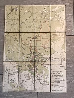
Umgebungskarte der Kurstadt Marienbad, 1 : 50.000 (ca. 66 x 72 cm)
Verlag: Marienbad : E. A. Götz, 1111
Sprache: Deutsch
Anbieter: Antiquarische Fundgrube e.U., Wien, Österreich
Verkäuferbewertung 5 von 5 Sternen

Karte
EUR 15,00
Währung umrechnenEUR 8,00 für den Versand von Österreich nach USAAnzahl: 1 verfügbar
In den WarenkorbLandkarte. 1 Bl. (gefaltene Karte) stark rissig, bestaubt u. etw. befleckt G1000a *.* Sprache: Deutsch Gewicht in Gramm: 130.
-
Umgebungskarte von Marienbad, Maßstab 1 : 15.000; unter besonderer Berücksichtigung der Wegmarkierung für Terrainkuren
Verlag: Marienbad, Egerländer Verlag Hans Lerch, 1910
Sprache: Deutsch
Anbieter: Antiquariat Liber Antiqua, Krems an der Donau, Österreich
Verkäuferbewertung 5 von 5 Sternen
Karte
EUR 75,00
Währung umrechnenEUR 29,90 für den Versand von Österreich nach USAAnzahl: 1 verfügbar
In den WarenkorbLandkarte. Terrain-Kurwegkarte. ca. 44,5 x 63,2cm ca. 1910, Karte der Umgebung von Marienbad, Maßstab 1 : 15.000, Teilstücke der Karte auf Leinen, grün aufgezogen, für das Alter eher, guter Zustand. Leinen an der Titelblattkante etwas ausgefranst. Sprache: Deutsch.
-
![Bild des Verkäufers für Marienbad und Tachau -Land: BÖHMEN/BAYERN (= Specialkarte der Österreichisch-Ungarischen Monarchie - 1:75 000 Zone 6 Colonne VII [Band: 4049]) zum Verkauf von ANTIQUARIAT.WIEN Fine Books & Prints](https://pictures.abebooks.com/inventory/md/md30288358426.jpg)
Marienbad und Tachau -Land: BÖHMEN/BAYERN (= Specialkarte der Österreichisch-Ungarischen Monarchie - 1:75 000 Zone 6 Colonne VII [Band: 4049])
Verlag: Kaiserlich-Königliches Militär-Geographisches Institut ca. 1895, Wien, 1895
Anbieter: ANTIQUARIAT.WIEN Fine Books & Prints, Wien, Österreich
Verkäuferbewertung 5 von 5 Sternen
Karte
EUR 92,40
Währung umrechnenEUR 42,00 für den Versand von Österreich nach USAAnzahl: 1 verfügbar
In den WarenkorbFormatangabe ca 50 x 37 cm, zu 8 Segmenten auf Leinen aufgezogen, Ausgabe: einfärbig ; Zustand: gut, partiell mit Kolor. Spezialkarte Österreich-Ungarn de 500 Landkarte.
-
A Guide to Marienbad and the Neighbourhood (With a Plan and Map of the Surrounding Country)
Verlag: Published by Franz Gschihay, Marienbad, 1887
Anbieter: Keoghs Books, Skipton, Vereinigtes Königreich
Verbandsmitglied: PBFA
Verkäuferbewertung 4 von 5 Sternen
Karte Erstausgabe
EUR 144,79
Währung umrechnenEUR 32,80 für den Versand von Vereinigtes Königreich nach USAAnzahl: 1 verfügbar
In den Warenkorb, [2], 53 pages, 2 folding maps with titles (including Neuester Situationsplan von Marienbad, double-sided Rundsicht von der Kaiserhohe am Hamelickaberg bei Marienbad) First Edition , repair to spine, some wear and marking to covers, tears at hinges of endpapers, vertical repair to length of upper folding map, in good condition , blue card, black titles in border to upper cover, black titles to lower cover 18.5 x 12.5 cms Paperback ISBN:
-
Marienbad & Surroundings Marianske Lazne Bohemia Austria-Hungary 1904 large map
Erscheinungsdatum: 1904
Anbieter: RareMapsandBooks, Dover, NH, USA
Verkäuferbewertung 5 von 5 Sternen
Karte
EUR 56,74
Währung umrechnenEUR 6,13 für den Versand innerhalb von/der USAAnzahl: 1 verfügbar
In den WarenkorbZustand: good. Umgebung von Marienbad.(Europe, Austria-Hungary, Hapsburg Empire, Bohemia, Czech Republic, Marienbad, Marianske Lazne). Issued 1904, Vienna by the K. K. Militarische geographisches Institut. Litho von Offizial Skukup. Detailed early 20th century color lithographed wmilitary map. Well preserved, nice looking example with pleasing age patina. Original fold lines as issued. Sheet Measures c. 25" H x 29" W. Engraved Area Measures c. 22 1/4" H x 28" W.[R24721].
-
![Bild des Verkäufers für Marienbad und Tachau -Land: BÖHMEN / BAYERN (= Specialkarte der Österreichisch-Ungarischen Monarchie - 1:75 000 Zone 6 Colonne VII [Band: 4049]) zum Verkauf von ANTIQUARIAT.WIEN Fine Books & Prints](https://pictures.abebooks.com/inventory/md/md30278020280.jpg)
Marienbad und Tachau -Land: BÖHMEN / BAYERN (= Specialkarte der Österreichisch-Ungarischen Monarchie - 1:75 000 Zone 6 Colonne VII [Band: 4049])
Verlag: Militärgeographisches Institut, Wien, 1881
Anbieter: ANTIQUARIAT.WIEN Fine Books & Prints, Wien, Österreich
Verkäuferbewertung 5 von 5 Sternen
Karte
EUR 103,40
Währung umrechnenEUR 42,00 für den Versand von Österreich nach USAAnzahl: 1 verfügbar
In den WarenkorbFormatangabe ca 50 x 37 cm, gefaltet zu 8 Segmenten, Ausgabe: einfärbig ; Zustand: ein kleines Loch, sonst gut Spezialkarte Österreich-Ungarn de 500 Landkarte.
-
Böhmen: Der Nordwestliche Teil Böhmens mit Einschluss der Badeörter Carlsbad, Franzenbad, Marienbad, König Otto-Quelle, und ihre Umgebungen, ferner Teplitz und die Umgegend bis Dresden, im verjüngten Masstäbe; nach den besten und neuesten Materialien zusammengestellt;
Verlag: Carlsbad, Franieck & Co.
Karte
EUR 145,00
Währung umrechnenEUR 29,00 für den Versand von Frankreich nach USAAnzahl: 1 verfügbar
In den WarenkorbPas de couverture. Zustand: Bon. Ohne Datum um 1855, auf Leinen aufgezogen, guter Zustand, die Eisenbahnlinien sind in Rot mit der Hand gezeichnet; 71x54,5 cm (Gesamtgrösse); gut erhalten; mit dem gestochenen Ex Libris und Inventarnummer der Bibliothek von Antoine d'Orléans (1824-1890) Sohn des Königs Louis-Philippe und spanischer Prinz;


